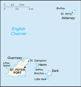
The Geography of Guernsey
The Geography of Guernsey
Channel Islander Geography
Location: Western Europe, islands in the English Channel, northwest of France
Geographic coordinates: 49 28 N, 2 35 W
Map references: Europe
Area: total: 78 sq km land: 78 sq km water: 0 sq km note: includes Alderney, Guernsey, Herm, Sark, and some other smaller islands
Area - comparative: about one-half the size of Washington, DC
Land boundaries: 0 km
Coastline: 50 km
Maritime claims: territorial sea: 3 nm exclusive fishing zone: 12 nm
Climate: temperate with mild winters and cool summers; about 50% of days are overcast
Terrain: mostly level with low hills in southwest
Elevation extremes: lowest point: Atlantic Ocean 0 m highest point: unnamed location on Sark 114 m
Natural resources: cropland
Land use: arable land: NA permanent crops: NA other: NA
Irrigated land: NA
Natural hazards: NA
Environment - current issues: NA
Environment - international agreements:
Geography - note: large, deepwater harbor at Saint Peter Port


