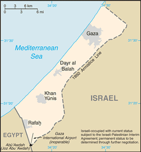
The Geography of Gaza Strip
The Geography of Gaza Strip
NA Geography
Location: Middle East, bordering the Mediterranean Sea, between Egypt and Israel
Geographic coordinates: 31 25 N, 34 20 E
Map references: Middle East
Area: total: 360 sq km land: 360 sq km water: 0 sq km
Area - comparative: slightly more than twice the size of Washington, DC
Land boundaries: total: 62 km border countries: Egypt 11 km, Israel 51 km
Coastline: 40 km
Maritime claims: Israeli-occupied with current status subject to the Israeli-Palestinian Interim Agreement - permanent status to be determined through further negotiation
Climate: temperate, mild winters, dry and warm to hot summers
Terrain: flat to rolling, sand- and dune-covered coastal plain
Elevation extremes: lowest point: Mediterranean Sea 0 m highest point: Abu 'Awdah (Joz Abu 'Auda) 105 m
Natural resources: arable land, natural gas
Land use: arable land: 29% permanent crops: 21% other: 50% (2002)
Irrigated land: 155 sq km; (note - includes West Bank) (2003)
Natural hazards: droughts
Environment - current issues: desertification; salination of fresh water; sewage treatment; water-borne disease; soil degradation; depletion and contamination of underground water resources
Environment - international agreements:
Geography - note: strategic strip of land along Mideast-North African trade routes has experienced an incredibly turbulent history; the town of Gaza itself has been besieged countless times in its history


