The Geography of Estonia
The Geography of Estonia
Estonian Geography
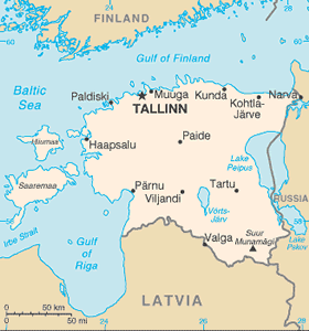
Location: Eastern Europe, bordering the Baltic Sea and Gulf of Finland, between Latvia and Russia
Geographic coordinates: 59 00 N, 26 00 E
Map references: Europe
Area: total: 45,226 sq km land: 43,211 sq km water: 2,015 sq km note: includes 1,520 islands in the Baltic Sea
Area - comparative: slightly smaller than New Hampshire and Vermont combined
Land boundaries: total: 633 km border countries: Latvia 343 km, Russia 290 km
Coastline: 3,794 km
Maritime claims: territorial sea: 12 nm exclusive economic zone: limits fixed in coordination with neighboring states
Climate: maritime, wet, moderate winters, cool summers
Terrain: marshy, lowlands; flat in the north, hilly in the south
Elevation extremes: lowest point: Baltic Sea 0 m highest point: Suur Munamagi 318 m
Natural resources: oil shale, peat, phosphorite, clay, limestone, sand, dolomite, arable land, sea mud
Land use: arable land: 12.05% permanent crops: 0.35% other: 87.6% (2005)
Irrigated land: 40 sq km (2003)
Natural hazards: sometimes flooding occurs in the spring
Environment - current issues: air polluted with sulfur dioxide from oil-shale burning power plants in northeast; however, the amount of pollutants emitted to the air have fallen steadily, the emissions of 2000 were 80% less than in 1980; the amount of unpurified wastewater discharged to water bodies in 2000 was one-20th the level of 1980; in connection with the start-up of new water purification plants, the pollution load of wastewater decreased; Estonia has more than 1,400 natural and manmade lakes, the smaller of which in agricultural areas need to be monitored; coastal seawater is polluted in certain locations
Environment - international agreements: party to: Air Pollution, Air Pollution-Nitrogen Oxides, Air Pollution-Persistent Organic Pollutants, Air Pollution-Sulfur 85, Air Pollution-Volatile Organic Compounds, Antarctic Treaty, Biodiversity, Climate Change, Climate Change-Kyoto Protocol, Endangered Species, Hazardous Wastes, Law of the Sea, Ozone Layer Protection, Ship Pollution, Wetlands signed, but not ratified: none of the selected agreements
Geography - note: the mainland terrain is flat, boggy, and partly wooded; offshore lie more than 1,500 islands


